
Lower Nam Phong Fm
Period:
Triassic, Jurassic
Age Interval:
Rhaetian-Hettangian (13, 14, 15)
Province:
Indochina Block: Khorat Plateau, Indochina Block: Loei Fold Belt
Type Locality and Naming
Type area: Nam Phong, Phu Kradung district, Loei province. Parent unit: Khorat Gr.
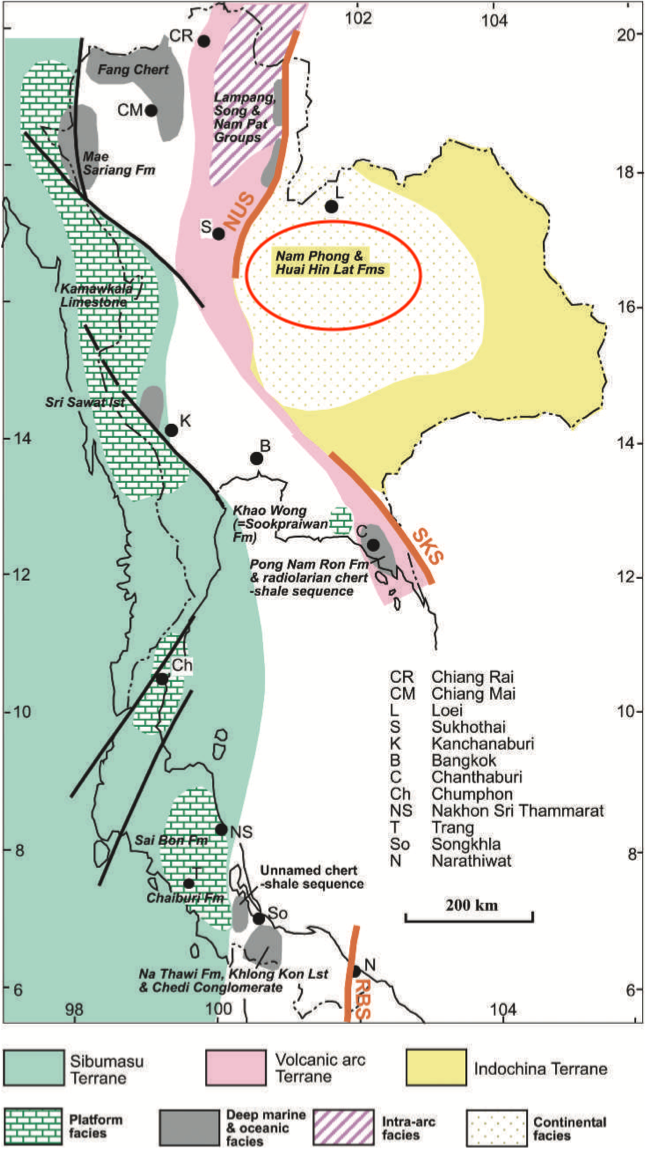
[Figure 1 : Generalized distribution of different Triassic sedimentary environments and some of the more important lithostratigraphic units, and their relations to the terranes. (The Geology of Thailand, 2011) page 146]
Synonym: หมวดหินน้ำพอง
Lithology and Thickness
"The Lower Nam Phong Formation consists of roughly equal proportions of interbedded claystones, siltstones and sandstones. … The lower half of the overlying Upper Nam Phong Formation often consists predominantly of thick-bedded to massive sandstones," Thickness: "mapping on seismic lines suggests it reaches a maximum thickness of c. 1000 m".[Booth, J. & Sattayarak N., 2011, Chapter 9 Subsurface Carboniferous-Cretaceous geology of NE Thailand]
Lithology Pattern:
Fine-grained sandstone
Relationships and Distribution
Lower contact
Huai Hin Lat Fm (unconformably = Indosinian II Event) and elsewhere the Permian Saraburi Gr or older units. "This formation onlaps the remnant paleotopography of the Indosinian II Unconformity (Fig. 9.17), with no evidence of any synsedimentary faulting." [Booth, J. & Sattayarak N., 2011, Chapter 9 Subsurface Carboniferous-Cretaceous geology of NE Thailand]
Upper contact
Unconformity (the Indosinian III Event) below the Lower Nam Phong Fm..)
Regional extent
The Khorat Plateau. "As mapped on the available grid of seismic lines the Lower Nam Phong Formation is essentially restricted to the central part of the Khorat Basin (sensu lato). It pinches out to the south and north (Fig. 9.4); however, its eastern limit cannot be determined on the available grid of seismic lines." [Booth, J. & Sattayarak N., 2011, Chapter 9 Subsurface Carboniferous-Cretaceous geology of NE Thailand]
GeoJSON
{"type":"Feature","geometry":{"type":"Polygon","coordinates":[[[100.86,17.97],[100.84,17.82],[100.73,17.64],[100.5,17.26],[100.28,16.84],[100.18,16.41],[100.28,15.88],[100.48,15.55],[100.45,15.3],[100.53,14.96],[100.66,14.73],[100.91,14.5],[101.11,14.45],[101.51,14.44],[102.13,14.69],[102.42,14.84],[102.67,14.92],[102.84,14.96],[103.08,14.98],[103.24,15.04],[103.43,15.12],[103.51,15.18],[103.65,15.34],[103.72,15.57],[103.73,16.03],[103.66,16.46],[103.45,16.87],[103.16,17.27],[102.66,17.53],[102.29,17.74],[101.89,17.99],[101.7,17.96],[101.63,17.81],[101.48,17.81],[101.34,17.66],[101.16,17.49],[100.98,17.53],[100.93,17.66],[100.99,17.81],[101.1,17.99],[100.86,17.97]]]}}
Fossils
Age
Previously, the combined Nam Phong Fm was considered to span the Rhaetian- Hettangian (Geology of Thailand, 2011, page 139, Fig 6.2 Correlation chart of the principal Triassic sedimentary lithostratigraphic units in Thailand.). However, recognition of a major Unconformity III Event in middle, implies the Upper Nam Phong Fm spans the Late Jurassic (Oxf-Kimm here), and only the Lower Nam Phong Fm spans the Rhaetian-Hettangian following Booth, J. & Sattayarak N., 2011, Chapter 9 Subsurface Carboniferous-Cretaceous geology of NE Thailand.
Age Span:
Beginning stage:
Rhaetian
Fraction up in beginning stage:
0.0
Beginning date (Ma):
209.56
Ending stage:
Sinemurian
Fraction up in the ending stage:
0
Ending date (Ma):
199.36
Depositional setting
Fluvial-alluvial. "These sediments are interpreted to have been deposited in alluvial fan and fluvial floodplain environments, possibly with limited areas of shallow lakes or swamps. Mudlogging reports often describe thin limestones, more frequent towards the base of the formation. These probably represent bands of calcareous nodules from caliche soil horizons." [Booth, J. & Sattayarak N., 2011, Chapter 9 Subsurface Carboniferous-Cretaceous geology of NE Thailand]
Depositional pattern:
Additional Information
Compiler:
Wen Du - modified from- Chonglakmani, C.P., 2011, Chapter 6 Triassic and Booth, J. & Sattayarak N., 2011, Chapter 9 Subsurface Carboniferous-Cretaceous geology of NE Thailand in Ridd, M.F., Barber, A.J., and Grow, M.J., editors, The Geology of Thailand, Geol. Soc. of London.; Lexicon of Stratigraphic Names of Thailand of 2013.